ESC 关闭 · 滚轮缩放 · 双击切换缩放 · 拖拽移动
R 重置 · +/- 键盘缩放 · ↑↓←→ 键盘移动
![Chang-hai et Zi-Ka-Wei [Shanghai et Zicawei]](/_astro/vcMap_ID-335_No-1.BXsymVJy_U1trl.avif)
100%
作者 (Author): Capitaine Gadoffre, infanterie coloniale
年份 (Year): 1901
尺寸 (Size): 95 x 114 cm
“Carte dressée par le Capitaine Gadoffre, avec la collaboration des Lieutenants Muselli et Ringue et du Soldat Bouat. 16e régiment d’Infanterie coloniale.” “Carte provisoire faite sans instruments de précision - angles déterminés à la boussole Peigné - distances mesurées au pas étalonné.”
Also available on Earthworks at Stanford University
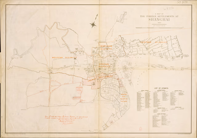
"Published for the North China Herald and North China Daily News Offices, Shanghai"
Caption in French and English
Compiled and arranged from the following maps [see list] for the Intelligence Branch, China Expeditionary Force. 1. Map of Whampoo by A.M. Bisbee 2. Map of the Foreign settlements, Shanghai 3. Shanghai Spoting Mao. Between the Soochow & Sicaway Creeks by C.Cornius 4. Maps of Creeks between the Woodlands & Hongkew Creeks 5. Captain Tweddle's survey of Ditches east of Hongkew Creek 6. Survey between the French Sicaway and the River by S. Bryant Rowe 7. Chinese map of the city and suburbs 8. Sketch map of the camps near Arsenal 9. Sketch map of Pootung 10. Plann shewing houses west of Defense Creek 11. Plan of Shanghai from Intelligence Branch Also available on Earthworks at Stanford University
![Chang-hai et Zi-Ka-Wei [Shanghai et Zicawei]](/_astro/vcMap_ID-335_No-1.BXsymVJy_ZlymKa.avif)